
No higher resolution available.
Avalae_Map_2020-06-24.png (306 × 303 pixels, file size: 199 KB, MIME type: image/png)
| This file and the description below the red line are loaded from our central media archive atys.wiki.ryzom.com. |
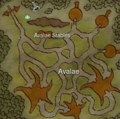
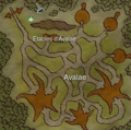
from BM, with kara tp, stable. Detailled version
EN version
FR version


File history
Click on a date/time to view the file as it appeared at that time.
| Date/Time | Thumbnail | Dimensions | User | Comment | |
|---|---|---|---|---|---|
| current | 12:36, 24 June 2020 | | 306 × 303 (199 KB) | Craftjenn | Category:Map images Category:Verdant Heights |
File usage
The following page links to this file: