m |
|||
| Line 71: | Line 71: | ||
| 4 regions, some resources up to 250. | | 4 regions, some resources up to 250. | ||
|} | |} | ||
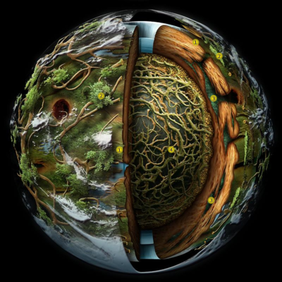
| − | + | ==Image Map <ref>Created by Online Image Map Editor (http://www.maschek.hu/imagemap/index)</ref>== | |
| + | <imagemap> | ||
| + | File:Geography-1.png|400px | ||
| + | rect 540 104 570 134 [[Bark]] | ||
| + | rect 320 407 355 442 [[Bark]] | ||
| + | circle 622 160 18 [[Canopy]] | ||
| + | circle 286 271 20 [[Canopy]] | ||
| + | circle 606 280 19 [[Prime Roots]] | ||
| + | circle 598 567 16 [[Prime Roots]] | ||
| + | circle 485 424 38 [[Kernel]] | ||
| + | #<!-- Created by Online Image Map Editor (http://www.maschek.hu/imagemap/index) --> | ||
| + | </imagemap> | ||
{{clear}} | {{clear}} | ||
---- | ---- | ||
<references/> | <references/> | ||
---- | ---- | ||
Revision as of 21:33, 11 February 2020
Motivation
This text straddles gameplay and roleplay. Besides the word geography itself is only very moderately RP [1]. The problem is that we don't have any RP word to designate the groups of regions nor the level (and other things like the classification of the living). Silan's NPCs send refugees to The Continent and not the continents. This is obvious when you edit the pages and especially the templates, be it the "ambers" or the navigation templates. It therefore seems to me necessary to establish a clear convention to remove the current ambiguities. This is, moreover, the same approach that the Lore has in specifying what is called an "island" and which is not specified anywhere in the wiki. It is also the same approach that led the first editors to make the pages of the "small glossary". If we don't do this, we will continue to confuse groups of regions, nations and ecosystems with all the resulting misunderstandings. (cf for example: Template:RegionInfoBox or even Ryzom armory: https://www.ryzomarmory.com/database/continent/3)
Physical Geography of Atys
- Atys is a living planet:
We mean, of course, that its constituents have for origin living organisms, whether plant or animal, but also that its structure includes living entities, plant to our knowledge. This makes its origin particularly mysterious.
- Away from the atmosphere, Atys is composed of several layers:
- The outer layer is the Canopy. Inaccessible, except maybe with a Flyner. Some canopy bets, dense enough, could be habitable.
- The layer immediately below is called the Bark, itself made up of several sub-layers, at different altitudes, which are sometimes old canopies.
- The known part of the bark is divided into continents, subcontinents, islands, regions and localities.
There is currently only one accessible continent, that of the New Earths. As far as we know, the Old Lands must have had a similar structure. This is why, in general, only of THE continent is spoken of. It is divided into four subcontinents and islands:- The subcontinents of the New Lands are: Aeden Aqueous, the Burning Desert, Witherings and Verdant Heights. Apart from Aeden Aqueous, which also contains island-regions, the subcontinents are made up of related regions.
- The region is the smallest geographical entity. It may have several ecosystems and is not necessarily under the control of the predominant nation of the region. One of the characteristics of the region is its danger index [2], which qualifies on one hand the danger to which one is exposed when travelling through it and on the other hand the quality of the resources available there (both are objectively linked). The "localties" are places in the regions named for their particular interest, appearance, history or simply by use.
- The islands: Essentially the Nexus, Silan and Almati Wood [3]. The islands are most often made up of a single region, bordered by cliffs or water. There is in fact no difference between islands and continents except for the size and the division into regions. Like any rule, it suffers from exceptions: To the Nexus is attached a region of the Verdant Heights: the (marauder city) because it is only accessible through it.
- The known part of the bark is divided into continents, subcontinents, islands, regions and localities.
- The next layer is the Prime Roots layer. Because of the differences in altitude some regions of the Prime Roots may be adjacent to regions of the bark. These regions sometimes communicate with the bark through gaps, faults or collapses.
Whether this layer should be considered as a subpart of the bark or as a clean layer is still the subject of fierce discussions between geographers and is still not clear-cut to this day. The Prime Roots layer is characterized by its particular ecosystem. The resources are different there, and confer to the fauna and flora a higher energy amount than elsewhere, despite the absence of external light. When several contiguous regions are connected, such as the Lands of Umbra for example, we speak of super-region.- The known and accessible part of the Prime Roots contains two super-regions: the Lands of Umbra (four regions) and the Wastelands (three regions) and two isolated regions: Abyss of Ichor and Under Spring. The regions that served as a refuge for the homins following the Great Swarm are no longer accessible in practice today [4].


- Examples, exceptions:
Sub-Continent Verdant Heights Aeden Aqueous Super-Region Lands of Umbra Ecosystems Forest (main), Jungle, Desert. Lakelands Ecosystems Prime Roots Danger index 50 -250 50 -250 Danger index 150 - 200 War [6] Neutral Neutral War Yes Total Area 20.09 km². 22.63 km². Total Area 8.29 km². Comment 7 regions In fact a one sub-continent (super-region?, 3 regions) and 5 Islands Comment 4 regions, some resources up to 250.
Image Map [7]

- ↑ shouldn't we say Atys(s)ography?
- ↑ the "level".
- ↑ The Almati Wood actually belongs to the Old Lands.
- ↑ There is still a link, the Oflovak's Road, of which only part is under control. It is still travelled by groups of refugees from the Old Lands.
- ↑ the indicated regions do not represent the layout of the New Lands, it is simply a theoretical example.
- ↑ PvP
- ↑ Created by Online Image Map Editor (http://www.maschek.hu/imagemap/index)