m (→The map's toolbar) |
m |
||
| Line 63: | Line 63: | ||
* shared_keys.xml (to share macros with several toons) and shared_interface.icfg exists as well | * shared_keys.xml (to share macros with several toons) and shared_interface.icfg exists as well | ||
* On [[Various applications]], for windows you'll find information about a windows software to export your landmarks into an excel sheet, import, and more... | * On [[Various applications]], for windows you'll find information about a windows software to export your landmarks into an excel sheet, import, and more... | ||
| + | |||
| + | === Persistent Map zoom level=== | ||
| + | Source: https://app.ryzom.com/app_forum/index.php?page=topic/view/32376/1 | ||
| + | |||
| + | For example, if your landmarks_<char>.xml looks like: | ||
| + | <landmarks continent="testroom" type="user"/> | ||
| + | <landmarks continent="tryker" type="user" zoom="6"> | ||
| + | <landmark type="29" x="16658.34" y="-31713.11" title="Kami N"/> | ||
| + | |||
| + | then, change it to: | ||
| + | |||
| + | <landmarks continent="testroom" type="user"/> | ||
| + | <landmarks continent="tryker" type="user" zoom="6"> | ||
| + | <landmark type="29" x="16658.34" y="-31713.11" title="Kami N"/><br /> | ||
| + | if(!element.attributes.zoom) | ||
| + | zoom = 1 | ||
| + | else | ||
| + | try { | ||
| + | zoom = int(element.attributes.zoom) | ||
| + | except | ||
| + | zoom = 1 | ||
| + | } | ||
==Links== | ==Links== | ||
Revision as of 01:33, 22 October 2022
This is a Map FAQ:
- I noticed that many young people did not see "Back" (and do not have access to the map of the continents of Atys). :)
- In addition, the maximum number of markers has been modified, research and events are new features....
- a Patch (in March 2020) added a command, to hide/show landmarks: /showHideUserLandMark (more on Special command).
For new comers, start with the User Manual, the sections Maps and compas.
Contents
The map's toolbar
From left to right (3 lines): ![]()
Back (to navigate in maps), ; zoom + ; zoom - ; center the map (on your position, useful after a big fast zoom) ; ? to search ; Filters on your Landmarks (new in JA 2620) ; DE icon (see below #Dynamic Event)
Below: IG hour and date[1] ; climatic conditions (or cc, important for Harvesting).
The map - basics
You can open/close the map with m or using the toolbar - not to be confused with the compass or radar (you can retrieve an existing landmark on your map and add it to the compass).
- The map (M) has 3 zooms. To change the view, or use the scroll mouse on map, and/or clic on a town to see its map.
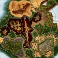
Atys global view: to see it, clic on "back". Useful when you need to go in an other continent (using vortex).
Usual view. Here you can organize your flags - flags color change regarding the category (bandits, path, source...).
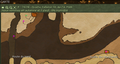
"Detail" view, for towns (here Pyr). User back to un-zoom


- To add to compass a direction: right clic on the compass, you'll see a menu (target, Missions, Mark, animal, team... and a zoom for the compass).
- To use target: either after a macro, or after a tar (ex: /tar "harmful ragus"), space bar = in front of you (see all keyboard shortcuts by holding K down)
- category:Starting Out as a lot of nice stuff for beginners.
The map - FAQ
- Coming back after a long absence? Patch 2020, Patch 2019... summarize the big changes in the game (with links to forum posts).
- Mektoubs/Gubani and Zig are shown on the map, but not your apartment or GH (add a mark on tour map). More on Mektoub FAQ
- Team members appear on the map. Not his friends (F) nor guild or league members.
- We see the resurrection points (rez points) only for the active subcontinent (the one where we are).
- You can now see the distance by right-clicking on the map.
- The landmarks on the map are stored in a landmarks_toonname.xml file, located in a save folder (which is basically under a 0 or 1 folder).
- a Patch (in March 2020) added a command, to hide/show player landmarks: /showHideUserLandMark (more on Special command).
- Now you can access Dynamic Events (Kiting invasion, puzzles, Storyline's Nexus Events...)
- The map take too much space on your screen (13")?
- use the 4 desktops (very often F3 is "less loaded")
- maintain the Fx key is very usefull, with x=1 to 4 (for ex, to add a 2nd "hand" toolbar)
Dynamic Event
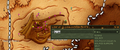
Dynamic Event: since JA2603 (June 2019), a blue Events button has been added to the map toolbar (1 in the image below). This blue Events button makes a transparent layer appear/disappear on top of the map, which is useless if there is no event in progress . This layer has a red and white button in its upper right part (2 on the image), which is inactive if there is no DE.
If a DE is in progress, then it is displayed on the map (in orange in the map toolbar: 1 Dynamic Events + a big blue dot on the map) and you can also keep a separate window open to monitor it. More at Dynamic Event.

Landmarks
Backup your files: quit game, and zip your folder save (check the date, to be sure it's the right one [2]) :p Your personal landmarks are held in a .xml file - named "landmarks_nameoftoon.xml" in the save folder.
To merge 2 files:
- quit the game, then
- copy the lines between <interface_config> into target file and
- relaunch the game. it will merge duplicate <landmarks continent> lines and remove duplicate markers.
If you want to share landmarks between characters on same computer, then rename landmarks file to shared_landmarks.xml
More on Ryzom location.
Tips
- shared_keys.xml (to share macros with several toons) and shared_interface.icfg exists as well
- On Various applications, for windows you'll find information about a windows software to export your landmarks into an excel sheet, import, and more...
Persistent Map zoom level
Source: https://app.ryzom.com/app_forum/index.php?page=topic/view/32376/1
For example, if your landmarks_<char>.xml looks like:
 <landmarks continent="testroom" type="user"/>
 <landmarks continent="tryker" type="user" zoom="6">
   <landmark type="29" x="16658.34" y="-31713.11" title="Kami N"/>
then, change it to:
 <landmarks continent="testroom" type="user"/>
 <landmarks continent="tryker" type="user" zoom="6">
   <landmark type="29" x="16658.34" y="-31713.11" title="Kami N"/>

if(!element.attributes.zoom)
  zoom = 1
else
  try {
   zoom = int(element.attributes.zoom)
 except
   zoom = 1
 }
Links
- In May 2019: JY 2603 patch
- to Atys and its Map with links to regions
- the Category:Geography
- 3D map https://sites.google.com/site/ryzommaps/3dmaps